


Kristiina Gaillard
Experte des voyages dans les Alpes et en Scandinavie
Appeler
Écrire
Choisissez les cookies que vous acceptez. Politique de confidentialité
Mesure d'audience
Google Analytics — Statistiques de visite anonymisées
Publicité ciblée
Meta (Facebook) Pixel — Publicités personnalisées
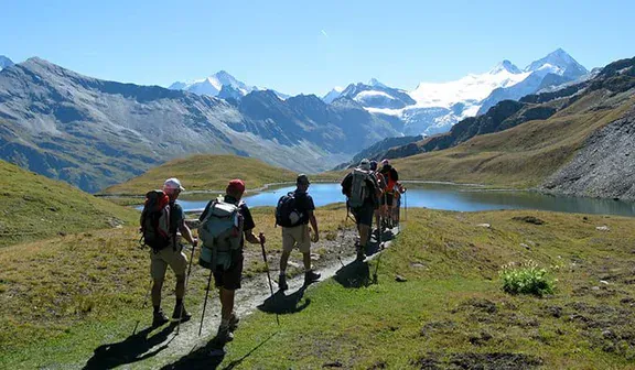
As a long-standing specialist in Alps hiking tours, Grand Angle has designed a route that captures the essence of the Valais region. This journey covers the eastern section of the renowned Walker's Haute Route, a classic high-altitude trek that connects the village of Arolla with the iconic town of Zermatt. It is an immersive experience in the heart of the Swiss high mountains.
This self guided tour Europe is crafted for experienced hikers, taking you from the Val d’Hérens to the Mattertal valley by way of remote mountain passes like the Forcletta and Augstbord. The path reveals a steady progression of panoramic views of the region's legendary 4,000-meter peaks: Dent Blanche, the Weisshorn, Zinalrothorn, and ultimately, the unmistakable silhouette of the Matterhorn upon your approach to Zermatt. The final stage incorporates the famed "Europaweg," a spectacular balcony trail offering exceptional views.
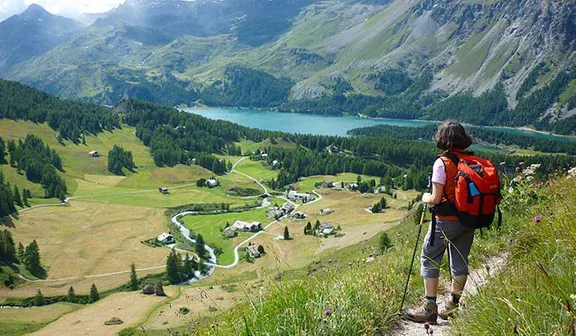
To ensure you can focus on the trail, we manage the logistics, including daily luggage transportation between your accommodations. Evenings are spent in the comfort of traditional hotels and mountain lodges in charming alpine villages like Les Haudères and Zinal. This itinerary strikes a deliberate balance between challenging, rewarding Europe hiking tours and the discovery of authentic mountain culture.

Arrival to Arolla and hotel check-in, available after ~3pm. This is the highest village in the Valais canton, at the edge of the last sparse forests of Arolla Pines and Larches. The glaciated north face of Mount Collon dominates the view South from this village sitting at the end of the Val d’Hérens.
This is a very beautiful hike that goes up to Pra Gra, (2,479m/8,133ft); it offers a huge panoramic view and goes into a cirque with scree and passes through the moraine edges of the glacier of the “Aiguilles Rouges”. You arrive at the refuge of the same name, which is a perfect spot for a break. From here you descend to the beautiful waters of "Lac Bleu" (Blue Lake). Then, you return to Arolla by foot and on to Les Haudères by bus. Enjoy a night at a hotel in the center of the village. It is a beautiful village in a wonderful setting at the foot of the “Dent Blanche” (the White Tooth).
About 5.5 to 6 hours of walking, 13.1km/8.1mi, +/-930m/3051ft. Daypack to carry.
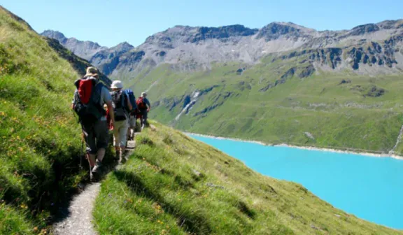
You will go up to the Torrent pass (2,919m/9,577ft) via Villa (1,742m/5,715ft), which is a village with a rustic hallmark. You will have an extraordinary view over the Grands Combins, Mount Fort and the Pigne d’Arolla. Next the hike goes to Lake Moiry. From here you can either take a bus or continue hiking to the beautiful traditional village of Grimentz. Hike via Bendolla, where you can use a ski lift to reach Grimentz. After visiting the village, entirely built with larches, you will take a bus to Zinal.
About 4.5 to 5 hours of walking, 11.3km/7mi, up to +1180m/3875ft, -670m/2200ft (there can be less climbing depending on where a morning taxi drops you off, provided you pay an extra charge and plan a taxi from Les Haudères instead of the bus). Daypack to carry.
Optional Extra Hike: Moiry Lake to Bendolla (ski lift to Grimentz), about 2 hours of walking, 6.4km/3.9mi, +223m/730ft, -357m/1170ft
Optional Extra Hike: Bendolla to Grimentz, about 1.5 to 2 hours of walking, 2.4km/1.5mi, -545m/1790ft.
Optional Extra Hike: Moiry Lake to Grimentz, about 1.5 to 2 hours of walking, 6km/3.7mi, -665m/2180ft.
Itinerary : Main Itinerary: Torrent Pass
                  Optional Extra Hike: Moiry Lake to Bendolla (ski lift to Grimentz)


                  Optional Extra Hike: Bendolla to Grimentz
Accommodation : 3* hotel in Zinal
Option A Main Itinerary: Torrent Pass
Option B Optional Extra Hike: Moiry Lake to Bendolla (ski lift to Grimentz)
Option C Optional Extra Hike: Bendolla to Grimentz
The “Roc de la Vache” (2,581m/8,468ft) lookout, south of the Zinal valley, offers breathtaking views over the Moming glacier, the Zinalrothorn (4,221m/13,848ft) and the north-east side of the “Dent Blanche”. You then return to Zinal for a 2nd night in this relaxing town.
About 5 to 6 hours of walking, 14.7km/9.1mi, +/- 945m/3100ft. Daypack to carry.
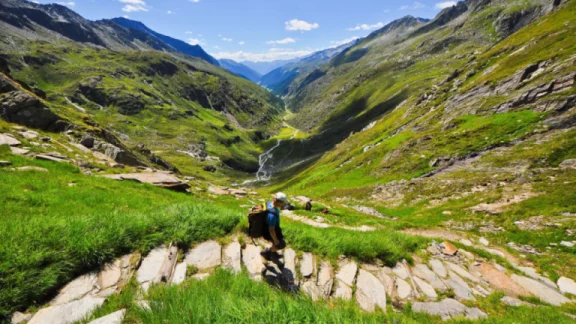
You will take a path on a balcony that overlooks the Val d'Anniviers (valley). It is a flat balcony following a contour line. Behind you, stands the towering Matterhorn and Zinal peaks. You will walk via the Forcletta pass (2,874m/9,429ft) and go down through a pastoral Alpine landscape, in the middle of meadows and forests of larches to Grüben/Meiden (1,822m/5,978ft). Do not forget to admire the marvelous chalets in this charming village and the stunning Turtmann glacier.
About 6.5 to 7 hours of walking, 16.9km/10.5mi, +1215m/3985ft, -1056m/3465ft. Daypack to carry.
You will start your walk by meandering through forests of Larches and Arolla Pines. You hike through a stunning valley past a small glacial lake, before going over the Augstbord pass (2,894m/9,495ft). This creates the natural border between the Turtmanntal and the Mattertal. You can make an optional side hike to the Schwarzhorn (3,201m/10,501ft), for the unique panoramic view stretching from Mont Blanc to the Monte Rosa massif. Then, you descend to the hanging hamlet of Jungen (1,955m/6,414ft). It is a magnificent site with a Baroque chapel and the view of the Nadelhorn and Monte Rosa massif. From Jungen, you can either take a cable car or continue hiking to reach St. Niklaus (1,127m/3,697ft). Transfer by train to Täsch.
About 5 hours of walking, 13.2km/8.2mi, +1111m/3645ft, -962m/3155ft. Cable car option from Jungen to St. Niklaus. Daypack to carry.
_Optional Extra Hike: Jungen to St. Niklaus, about 1.5 to 2 hour
Departure possible anytime between early July and mid-September.
Please Note: the beginning of the season has a strong risk of snow and snowy conditions on the trail.
Price Per Person, in double occupancy room:
| Departure Period | 2 to 3 People | 4 to 5 People | 6+ People |
|---|---|---|---|
| From 06/07/2026 to 15/09/2026 | 2225 € | 1885 € | 1775 € |
| From 06/07/2027 to 15/09/2027 | 2320 € | 1965 € | 1850 € |
► Extra Night(s)
Kristiina Gaillard
Experte des voyages dans les Alpes et en Scandinavie
Clémence Rouchez
Expert des voyages en Europe
Difficulty level 4/5, moderate to difficult hiking. About 3 to 7 hours of hiking per day in rocky mountainous terrain, up to 16.9km/10.5mi in distance daily. Expect +300 to 1,200m/985 to 3,937ft of daily ascents. Highest elevation reached on this trip is 2,918m/9,574ft.
You only need to carry a small backpack during hikes with the necessary items for the day. Your luggage will be transported by vehicle to next accommodations. Your luggage will arrive in the early evening each day.
Limited to 1 bag transported per person and a maximum weight of up to 15kg/33lbs per bag.
Possible for groups of 2 and above. Solo hikers are not allowed on this trip due to safety concerns.
Departures are possible anytime between early July and mid-September.
*Please be advised that the beginning of the season has a strong risk of snow and snowy conditions on the trail.
8 days / 7 nights / 6 days of hiking
On day 1 in the afternoon at hotel check-in (~3pm) in Arolla.
On day 8 in Zermatt upon hotel check-out (~10am) in Zermatt.
Self-guided tour, without a human guide. A digital travel packet (documents available in English, French & German) will be sent by email that includes access to our smartphone travel application for navigating hikes and accessing local maps (available in English only), the list of booked accommodations, any included travel vouchers and all the detailed information needed for a successful trip. If desired, we can provide a printed version of the travel packet for an additional fee. It will be waiting and available at the 1st accommodation of the itinerary with maps, topo guide and travel folder. This must be requested at the time of booking. There is no welcome meeting at the arrival hotel or general orientation meeting for this tour.
Accommodation / Catering
7 nights in private double occupancy rooms. From mountain lodges to 3* hotels, 1 night in a simple mountain lodge hotel with no en-suite bathroom option (Grüben). All other nights have en-suite bathrooms.
Dinners and Breakfasts: Included and served at hotels (except dinners in Tasch & Zermatt). These nights there are multiple restaurant options to choose from in town near accommodations. Lunches: It is always possible to ask for picnic lunches at the hotels, but you will also find grocery stores in all the villages to plan your own lunches. (Except in Grüben).
*Please let us know when you register if you are allergic to anything or if you have a special diet; we will do our best to have hotels adapt your meals.
It is possible to add extra nights before, during or after your tour in Arolla, Täsch or Zermatt. Please contact our sales team for availability and rates.
This tour starts in Arolla, Switzerland
This tour ends in Zermatt, Switzerland
The nearest airport to Arolla is Sion (SIR) Airport which is 75km/24mi away, but this airport has very limited flight options. There are better nearby larger international airports to use including Geneva (GVA), Zurich (ZRH) and Milan Malpensa (MXP). From any of these options a train can be planned to get to Sion (then bus to Arolla) or Zermatt. There may be private taxi options, but the costs will be high for this option from any of the international airports to Arolla/Zermatt.
From Zermatt, a great number of trains travel to Sion and/or other destinations (international airport cities). Zermatt is easily reached by train from many regional destinations.
From the Sion main railway station, you then take a taxi or bus to Arolla passing through Les Haudères. From Sion to Arolla thereare PostBus options (39km/24mi) at multiple times daily.
Pendolino or Eurocity Train (Milan - Sion - Geneva)
Website to see Train schedules: The SBB online portal for timetable, trains and public transport
Website to see bus schedules: Timetable and ticket purchases (postauto.ch)
The common arrival route is driving from Sion – Evolène – les Haudères – Arolla.
Parking - You can park your car at the first hotel, with advanced notice.
Travel story
Would you like to share your best moments of the trip and share your experience with the greater Grand Angle hiking community? Send us your story and some photos illustrating your words that we can consider publishing on our blog.
Responsible tourism
Since 2025, Grand Angle has been recognized as a Travelife Partner, an international label that certifies our responsible practices regarding the environment, ethics, and sustainable management, both within our company, with our partners, and in the organization of our trips.
This label, the second level of a rigorous international certification, attests to our concrete actions in favor of responsible tourism. We are actively working toward the next level, Travelife Certified, in line with our sustainable development policy.
It is the client’s responsibility to arrive prepared with the items listed below to help insure a safe and enjoyable trip.
The following items are required for this trip unless otherwise noted. When packing, think layered clothing systems that work together and can be easily added or removed.
Important Note: Please, no cotton hiking/cycling clothes. Synthetic clothing is very efficient in drying quickly. Merino wool material clothing is also efficient in drying quickly, is comfortable to wear and has the advantage of not developing a bad odor after use.
After years of experience planning adventure travel around the world, we've learned that anything can happen, and every traveler should carry a basic personal first aid kit. We want to ensure our guests are well-prepared and make smart informed travel decisions. In many of the places we operate trips, it may be challenging to find certain medications and/or first aid supplies, and sometimes common items you desire may not be available in the destination you are travelling. That's why it's good to be prepared and carry a small supply of first aid supplies, any prescription medication, and/or over-the-counter medications you may require during your travels.
We recommend discussing your travel plans, vaccination requirements, and any medication usage with your primary healthcare provider before embarking on our trips. This helps ensure you have a safe and enjoyable travel experience.
Here is a basic list of what we think makes a good personal travel first aid kit:
PACKING FOR TRAVEL: It is recommended that you prepare your items in the following manner for your travels to this trip.
“Carry-on Bag(s)” - This is the bag you will bring with you on the plane. We recommend all your pertinent information be in this bag (passport, travel documents, etc.) as well as your most important gear items (hiking footwear, jacket, prescription medication, etc.) in case any checked luggage items becomes lost or delayed.
“Checked Bag(s)” - This bag will be checked and contain the rest of your personal items (clothing and gear, etc.).
Important Note: Again, it is recommended to either wear or pack in your “Carry-on Bag” the main gear items you need for this trip vs. putting them in your checked “Travel Bag” (in case luggage is delayed). Hiking footwear is probably the hardest item to replace last minute if items become lost or delayed past the intended start date of the trip. Lost or delayed luggage has become more and more common in major airports for international travel since the global pandemic.
LUGGAGE MANAGEMENT DURING TRIP: During this trip, the packing system needs to be in 2 bags.
Extra Luggage - “Checked Bag(s)” & ”Carry-on Bag(s)”: This bag will contain all the items you want to bring along on the trip. It will be transferred by vehicle/taxi, and you will have access to it at the end of each day of activity, but not throughout the day. Extra luggage is not allowed or easily stored on this trip beyond the 1 bag per person requirement. Maximum 15kg/33lbs per bag per person.
Day Backpack (not provided): All guests will need a backpack, which they will be responsible for carrying during hikes. Items in this bag should include anything you may need throughout the day during the trip. (i.e. rain gear, warm layers, water, sunscreen/lip balm, snacks/food, camera/phone, etc.).
Switzerland, the Swiss Confederation, capital city: Bern.
Travellers from the European Union, including children, need a valid identity card or passport. Check with the authorities in your home country for the conditions of entering this destination.
Do not forget your card and/or policy details for your health insurance and/or travel insurance.
Switzerland Country Code: +41
European Emergency Services: 112
Swiss National tourist information office in Zurich Website: Switzerland Travel & Vacation | Switzerland Tourism (myswitzerland.com)
Valais Tourism Office Website: Holidays, Leisure, Gastronomy, Live & Work | Valais Switzerland
Evolène Region Tourism (regional tourist information office) Phone: +41272834000 Website: Welcome to Evolène Region | Evolène Région (evolene-region.ch)
Zermatt Tourism Office Website: Zermatt: Holidays in Switzerland & the Alps
Central European Time (CET/UTC+1) and Central European Summer Time (CEST/UTC+2) during daylight saving time.
In the Valais canton, French and German are spoken. Usually some English is spoken in all tourist areas.
The Swiss Franc (CHF) is used in all of Switzerland.
Change: possible in all railway stations, post offices or banks.
Evolene – 1:25,000, Vissoie – 1:25,000, Val d’Hérens - 1:25,000, Val d’Anniviers - 1:25,000, St Niklaus - 1:25,000, Zermatt / Gornergrat - 1:25,000
Ce voyage n'a pas encore d'avis. Retrouvez les avis de nos voyageurs sur des voyages similaires.
— Les paysages sont superbes chaque jour et ça vaut vraiment le coup de grimper. C’est un vrai plaisir de pouvoir faire des pauses dans les refuges, ça fait partie du charme. Par contre, je déconseillerais de faire ce circuit en pleine canicule, car les hébergements deviennent vite très chauds le soir.
Mariette 27/12/2025 • Tour du Mont Blanc à pied et sans guide en 10 jours par Courmayeur - Randonnée
— Mis à part le Refuge Elisabetta et le Road Book qui ne fonctionnait pas toujours très bien, tout s’est très bien passé !
Helene 27/12/2025 • Tour du Mont Blanc à pied et sans guide en 10 jours par Courmayeur - Randonnée
— Je suis très heureuse d’avoir fait le tour du Mont Blanc magnifiques paysages

À partir de
1 395 €
★★★★☆ 4,3/5 (6 avis)

À partir de
605 €
À partir de
Prix sur demande
À partir de
1 370 €

À partir de
1 350 €
★★★★☆ 4/5 (2 avis)

320 voyages

559 voyages

71 voyages

20 voyages

30 voyages

5 voyages

3 voyages

337 voyages

337 voyages
337 voyages
337 voyages

316 voyages
171 voyages

170 voyages

169 voyages

169 voyages

169 voyages

167 voyages

144 voyages

130 voyages

128 voyages

126 voyages

126 voyages
120 voyages
105 voyages

104 voyages
98 voyages
92 voyages

88 voyages

83 voyages
Votre prochaine aventure
Aucune destination correspondante
Voyages confirmés uniquement
Appelez-nous